 1 / 10
Water Cycle Coloring Pages: 30 Labeled Diagrams of Watersheds, Wetlands, Glaciers, Caves and Cities
Instead of one water cycle drawn thirty times, this set follows rain, runoff and groundwater through thirty different places, from a glacier-fed river to a rain garden beside a house. Every page has its labels printed in boxes, and a color version of each diagram comes with it.
$3.99
Buy any 3 or more printables and save 20% at checkout.
- Download right after payment — link works for 30 days, up to 5 downloads
- Files arrive as a ZIP with your license PDF inside
- Secure checkout by Stripe · Refund policy
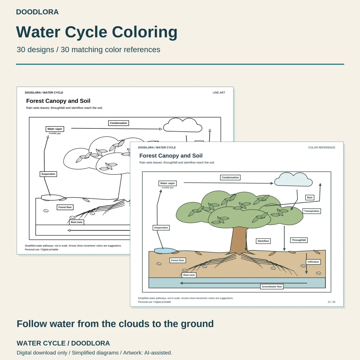
Rain falls somewhere different on each of these 30 water cycle coloring pages. A cloud, Water vapor and Condensation sit across the top of every page, and below them the drawing changes: a beaver pond, a city block with stormwater drains, a frozen tundra, a palm-covered coral island. Most pages cut away the ground so you can see where the water goes after it soaks in.
The 30 settings
| Group | Pages |
|---|---|
| Coasts and islands | 1 Coastal Watershed, 7 Mangrove Estuary, 8 Volcanic Island, 18 Rocky Fjord, 20 Coral Cay Freshwater Lens, 30 Barrier Island Lagoon |
| Snow, ice and cold ground | 2 Snowy Alpine Basin, 14 Glacier-Fed River, 15 Tundra Active Layer, 26 Snowmelt Meadow |
| Rivers and wetlands | 6 Marsh and Meandering River, 17 River Delta, 22 Oxbow Lake, 23 Beaver Wetland, 29 Waterfall Gorge |
| Forests, grass and wet hills | 3 Rainforest Headwaters, 5 Prairie Pond, 21 Forest Canopy and Soil, 27 Monsoon Hills |
| Dry places | 4 Desert Flash-Flood Wash, 19 Closed Salt Lake Basin, 28 Oasis and Dunes |
| Underground | 9 Limestone and Caves, 16 Woodland Spring, 25 Deep Aquifer Recharge |
| Places people built | 10 City Catchment, 11 Farm and Irrigation Pond, 12 Terraced Hillside, 13 Reservoir and Dam, 24 Rain Garden |
Each title has a one-line caption under it, for example “Water enters a closed basin and leaves mainly by evaporation” on page 19.
What the labels name
The labels are printed words in small boxes, so there is nothing to fill in. Water vapor, Condensation and Evaporation appear on all 30 pages, and Groundwater on 28. The rest depend on the place: Permafrost and Seasonally thawed layer on the tundra page, Freshwater lens and Saltwater under the coral island, Stormwater drain in the city, Stemflow and Throughfall under the forest canopy. Page 20 adds a cross section of the island, page 22 is drawn from above, and six pages carry a boxed close-up of the ground, such as fractured basalt on the volcanic island.
The shapes are plain outlines with big open areas, more science diagram than detailed scenery. The label text is small, so these work best for someone who can already read words like Infiltration.
The color references
Water is pale blue, soil and sand are tan, and plants are a soft green in the color file, with gray on the glacier and fjord mountains. The colors are suggestions, though a few pages are easier to follow with the reference beside you. On the tundra page it shades the thawed layer tan and the permafrost under it a pale blue-gray, so the two bands don’t blur together.
For printing, turn the page to landscape and keep the scale at 100%. The A4 PDFs carry the same diagrams if that is the paper you use.
Questions
- Is it the same water cycle diagram on every page?
- No. Each page is a different place with its own title and caption, such as Tundra Active Layer or Closed Salt Lake Basin. Six of them (pages 1, 4, 8, 12, 13 and 18) do share one hillside layout with the sea on the left, and what changes there is the ground, from coastal sand and alluvial gravel to cracked basalt and farm terraces.
- Are the arrows and sizes accurate?
- They show direction, not scale. Every page footer says the pathways are simplified and not to scale, and the start-here notes add that each page shows selected pathways rather than everything happening at that place.